|
| |
|
| |
Forum Perangkat GPS: Jual Garmin Oregon 550 GPS 3.2MP Camera (BARU) |
| |
|
|
| |
|
| Topik | : Jual Garmin Oregon 550 GPS 3.2MP Camera (BARU) |
| Penulis |
:  deandoubleneck deandoubleneck |
(GMT) 16:12:19 Minggu, 07 November 2010
|
| Tanggapan |
: 1 |
Dilihat: 1897
|
Kategori : Perangkat GPS
|
|
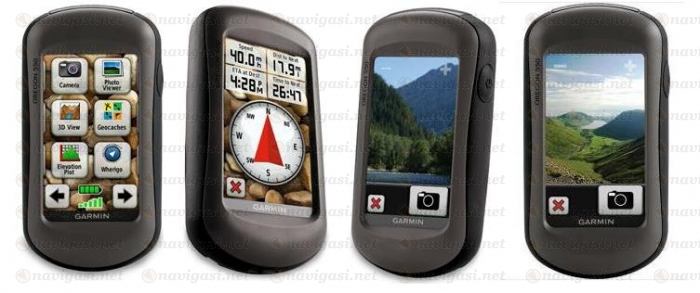
Jual Garmin Oregon 550 GPS Worldwide 3.2MP Camera(BARU).
Harga Rp 4.500.000 (Nego)
Telp/ SMS: 0812.8452.6978
ERICK JAKARTA
The navigator with the photographic memory - Oregon 550 combines rugged outdoor touchscreen navigation with a 3.2 megapixel digital camera. Add high sensitivity GPS, barometric altimeter, 3-axis electronic compass and microSD card slot. The result? A multipurpose device that will make your biggest adventures even more memorable.
Take pictures and Save Locations
Capture locations and memories with Oregon 550's 3.2 megapixel autofocus digital camera with 4x digital zoom. Each photo is automatically geotagged with the location of where it was taken, allowing you to navigate back to that exact spot in the future. Snap and view pictures in landscape or portrait orientation. With 850 MB of internal memory, you'll never miss a photo opportunity. To store online, simply connect Oregon 550 via USB and log into my.Garmin to upload and store your photos at Picasa, a popular photo sharing community for friends and families around the world. For more storage, insert a microSD card; you can even view pictures from other devices on microSD with Oregon's picture viewer.
Touch and Go
Oregon 550 makes rugged navigation effortless with a tough, 3-inch diagonal, sunlight-readable, color touchscreen display. The interface is easy to use, so you'll spend more time enjoying the outdoors and less time searching for information. Both durable and waterproof, Oregon 550 is built to withstand the elements. Bumps, dust, dirt, humidity and water are no match for this rugged navigator.
Get Your Bearings
Oregon 550 has a built-in 3-axis tilt-compensated electronic compass, which shows your heading even when you're standing still, without holding it level. Its barometric altimeter tracks changes in pressure to pinpoint your precise altitude, and you can even use it to plot barometric pressure over time, which can help you keep an eye on changing weather conditions. And with its high-sensitivity, WAAS-enabled GPS receiver and HotFix satellite prediction, Oregon 550 locates your position quickly and precisely and maintains its GPS location even in heavy cover and deep canyons.
Add Maps
Oregon 550 comes preloaded with a worldwide built-in basemap with shaded relief. Adding even more detail is easy: just insert a MapSource microSD card preloaded with detailed maps. Oregon can accept a variety of maps for any navigational need. Add detailed street maps to get turn-by-turn directions to your destination. Add select topographic maps to take advantage of Oregon's 3-D maps and elevation detail. Or add Bluechart g2 maps, which provide everything you need for a great day on the water, including depth contours, navaids and harbors.
Find Fun
Go paperless with Oregon 550 by quickly downloading information from Geocaching for up to 5000 caches, such as location, terrain, difficulty, hints and description. No more manually entering coordinates and paper print outs. Slim and lightweight, Oregon is the perfect companion for all your outdoor pursuits.
Share Wirelessly
With Oregon 550 you can share your waypoints, tracks, routes and geocaches wirelessly other Oregon and Colorado users. Now you can send your favorite route to a friend to enjoy or the location of a cache to find. Sharing data is easy. Just touch "send" to transfer your information to similar devices.
Features:
* Features:
* Automatic routing (turn by turn routing on roads): yes (with optional mapping for detailed roads)
* Electronic compass: yes
* Touchscreen: yes
* Barometric altimeter: yes
* Camera: no
* Geocaching-friendly: yes (paperless)
* Custom maps compatible: yes
* Photo navigation (navigate to geotagged photos): no
* Outdoor GPS games: yes (Wherigo only)
* Hunt/fish calendar: yes
* Sun and moon information: yes
* Tide tables: yes
* Area calculation: yes
* Custom POIs (ability to add additional points of interest): yes
* Unit-to-unit transfer (shares data wirelessly with similar units): yes
* Picture viewer: yes
* Garmin Connect™ compatible (online community where you analyze, categorize and share data): yes
Technical Specs:
* Physical & Performance:
* Unit dimensions, WxHxD: 2.3" x 4.5" x 1.4" (5.8 x 11.4 x 3.5 cm)
* Display size, WxH: 1.53"W x 2.55"H (3.8 x 6.3 cm); 3" diag (7.6 cm)
* Display resolution, WxH: 240 x 400 pixels
* Display type: Transflective color TFT touchscreen
* Weight: 6.8 oz (192.7 g) with batteries
* Battery: 2 AA batteries (not included); NiMH or Lithium recommended
* Battery life: 16 hours
* Waterproof: yes (IPX7)
* Floats: no
* High-sensitivity receiver: yes
* Interface: USB and NMEA 0183 compatible
* RoHS version available: yes
* Maps & Memory:
* Basemap: yes
* Preloaded street maps: no
* Ability to add maps: yes
* Built-in memory: 850 MB
* Accepts data cards: microSD™ card (not included)
* Waypoints/favorites/locations: 1000
* Routes: 50
* Track log: 10,000 points, 200 saved tracks
Harga Rp 4.500.000 (Nego)
Telp/ SMS: 0812.8452.6978
ERICK JAKARTA
 | |  | |  | | |
Maaf saya jarang online jadi kalau mau nanya langsung telp/ sms aja ya, makasi.. | |  | |  |
|
|
|
|
| |
|
deandoubleneck,
(GMT) 20:52:08 Kamis, 23 Desember 2010)
| |
.. SOLD !!
.. SOLD !!
.. SOLD !!
|
Anda diharuskan login terlebih dahulu sebelum memberi tanggapan. terlebih dahulu sebelum memberi tanggapan. |
|